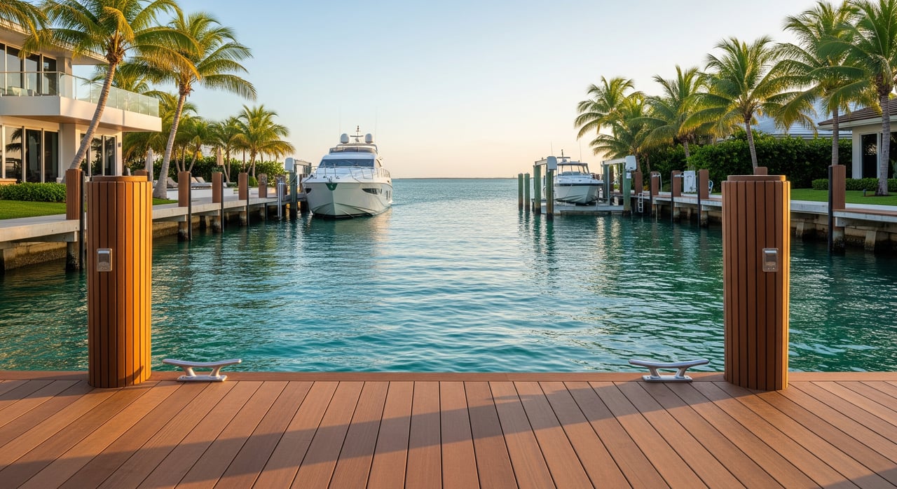
Thinking about a Royal Harbor home so you can take your boat straight to the Gulf? Waterfront listings often say “deep Gulf access,” but the details behind that phrase matter. You want confidence that your boat can get out at useful tides, clear any bridges, and dock safely at your property. In this guide, you’ll learn what deep access really means in Royal Harbor, how tides and clearances work, and the exact checks to complete before you buy. Let’s dive in.
Deep Gulf access, defined
“Deep Gulf access” typically means you can route from your dock to a maintained channel and out to Naples Bay, Gordon Pass, and the open Gulf without shallow bottlenecks or low fixed bridges that restrict your boat. In practice, you need to confirm two things:
- Horizontal access: Is there a direct, navigable route from your canal to Naples Bay and the Gulf without circuitous detours?
- Vertical and depth access: Do canal and channel depths support your boat’s draft at low water, and do bridges or utilities allow your boat’s air draft to pass?
This affects day-to-day use, insurance, resale value, and even emergency egress during storms. Getting it right means matching the lot, the route, and your boat.
Tides and chart datums in Naples
Most U.S. nautical charts use Mean Lower Low Water (MLLW) as the reference for depth soundings. That means the number you see on a chart is the depth above the typical low-low tide, not at today’s water level. Naples has a relatively small daily tidal range, often around 1 to 2 feet, but winds, barometric pressure, and storm surge can raise or lower levels. Always check local tide predictions when planning.
- Where to check tides: Use the official predictions from NOAA Tides & Currents to see forecasted lows and highs.
- How to read depth: If a canal is listed at 4 feet on a chart (referenced to MLLW) and the current tide is 1 foot above MLLW, your real-time depth is roughly 5 feet.
- Plan conservatively: Make docking decisions based on depths at lower tides and include a safety margin for uncertainty and shoaling.
Example: If your boat draws 3.0 feet and you want 1.0 foot of clearance under the keel or props, you need about 4.0 feet of water at MLLW. If your canal’s charted or surveyed depth is 4.5 feet at MLLW, you have roughly a 0.5-foot margin at the low reference.
Royal Harbor canals, dredging, and shoaling
Royal Harbor’s value is tied to canal access, but not all waterways are maintained the same way. You will encounter:
- Federally maintained channels: These are usually dredged and charted with published depths in approaches to Naples Bay and Gordon Pass.
- Locally maintained or private canals: Depths vary and may not be dredged on a set schedule.
- Natural shallows: Flats or seagrass areas near canal mouths or in parts of Naples Bay can limit draft.
To confirm conditions for a specific property:
- Review charted depths on NOAA Nautical Charts for Naples Bay and approaches.
- Ask the city or county whether there are canal as-built profiles or dredging records for the street or basin you’re considering. Collier County’s site is a good starting place for permit and environmental records: Collier County Government.
- Commission current depth soundings. A professional marine or hydrographic surveyor can provide a bathymetric survey referenced to chart datum, so you know the real numbers at the lot.
Permitting matters if dredging or dock work is needed. In Florida, dredging and marine construction typically require approval from state and federal agencies. Check the U.S. Army Corps of Engineers — Jacksonville District and the Florida Department of Environmental Protection for permit guidance, and be mindful of seagrass and mangrove protections that can influence what’s allowed and where spoils can go.
Shoaling is normal over time, especially after storms and seasonal changes. Even maintained channels can lose depth between dredge cycles, so rely on current data, not assumptions.
Bridges, lines, and overhead clearance
The vertical side of access is as important as depth. If the route from your dock to the Bay includes a fixed bridge, the published clearance at Mean High Water (MHW) governs the maximum air draft your boat can carry. Clearance changes with tide height, so lower tides may allow more room and higher tides less.
- Where to find clearances: Fixed bridges and their nominal clearances are shown on NOAA nautical charts. Temporary changes or restrictions are published in the U.S. Coast Guard Local Notice to Mariners.
- Check the whole route: Power lines or low utilities can be lower than a nearby bridge, and canal edges may have less vertical room than the centerline. Boathouse roofs or overhanging vegetation can create local overhead limits.
- Compare to your boat: Know your boat’s air draft including masts, radar arches, and fixed antennas. Compare it to the published clearance at the tide level you plan to transit.
A visual inspection at different tides is smart. If you can, run the route with a qualified local captain or surveyor before you close.
How to verify a Royal Harbor property
Use this step-by-step checklist to match your boat to a specific lot and route.
1) Know your boat’s numbers
- Draft and margins: Determine maximum draft when fully loaded. Add at least 6 to 12 inches of clearance for small planing boats, and 1 to 2 or more feet for larger keelboats or cruisers.
- Air draft: Measure the highest fixed point above the waterline. Include any radar arches, masts, or fixed antennas.
2) Confirm water depth and datum
- Get current soundings: Order a canal-front depth survey for the property, referenced to MLLW if possible.
- Crosscheck charts: Compare survey data to adjacent channels using NOAA Nautical Charts.
- Ask about maintenance: Request the date of the last dredge and whether the canal is on a recurring maintenance plan.
3) Review tides and surges
- Consult official tide predictions at NOAA Tides & Currents. Look at typical lows and seasonal patterns.
- Consider wind and pressure: Onshore winds or low pressure can raise water levels, while opposite conditions may drop them. Factor that into your safety margin.
4) Check headroom and overheads
- Verify bridges, lines, and structures along your entire path to Naples Bay and Gordon Pass.
- Use charted bridge clearances and adjust for the tide you plan to transit. Check the Local Notice to Mariners for any temporary changes.
5) Confirm legal status and dock options
- Review HOA and county rules on dock length, piling types, lifts, and boathouse structures.
- If dredging or dock work is needed, consult permitting guidance via the U.S. Army Corps of Engineers — Jacksonville District and the Florida DEP.
6) Map services and operations
- Note the nearest fuel, haul-out, and service yards you plan to use.
- Review local boating rules at the Florida Fish and Wildlife Conservation Commission to stay compliant.
7) Inspect at multiple tides
- Visit the property and run the route at both lower and higher tides. Observe any shallow sections, cross-currents, or overhead pinch points.
- Consider hiring a professional marine surveyor for a transit report.
8) Plan for insurance and resale
- Ask your marine insurer whether the berth, seawall condition, and access meet underwriting requirements.
- Think ahead about resale: Deep, reliable access often supports stronger demand.
Why this diligence protects your investment
Depths and clearances are the difference between daily-use convenience and seasonal frustration. A smart verification process helps you choose the right canal frontage for your boat, anticipate any upgrades you may want at the dock, and avoid surprises after closing. It also supports better insurance terms and helps protect long-term value.
Local resources worth bookmarking
- Tide data and station pages: NOAA Tides & Currents
- Charted depths and obstructions: NOAA Nautical Charts and viewer
- Federal permitting and channel maintenance: U.S. Army Corps of Engineers — Jacksonville District
- Florida coastal permits and seagrass rules: Florida Department of Environmental Protection
- Boating regulations and safety: Florida Fish and Wildlife Conservation Commission
- County permitting and environmental records: Collier County Government
- Temporary bridge or channel notices: U.S. Coast Guard Local Notice to Mariners
Work with a trusted local advisor
Choosing a Royal Harbor property is about more than a view. It is about the right water access for how you live and boat. With deep neighborhood knowledge and a concierge approach, you get clear guidance through due diligence, pricing, and negotiation while keeping your lifestyle goals front and center. If you are weighing lots or comparing canal segments, an experienced advisor can help you translate the numbers into day-to-day usability.
Ready to explore Royal Harbor homes with confidence? Reach out to Janine Monfort for private guidance and curated options.
FAQs
What does “deep Gulf access” mean for Royal Harbor?
- It means a property’s route to the Gulf is navigable without shallow bottlenecks or low fixed bridges that limit your boat, subject to verifying depths and clearances for your exact lot and route.
How do Naples tides affect canal depth and bridge clearance?
- Charted depths are referenced to MLLW and clearances are often at MHW, so real-time water level shifts the usable depth and headroom; check NOAA Tides & Currents before transiting.
How can I verify the depth at a specific Royal Harbor lot?
- Order a bathymetric survey referenced to MLLW, crosscheck NOAA Nautical Charts, and ask the county about dredging history for the canal.
Are there bridges or overhead lines on the route to the Gulf?
- You should inspect the entire path to Naples Bay and Gordon Pass, confirm bridge clearances on NOAA charts, and review the Local Notice to Mariners for temporary changes.
What permits might I need for dredging or dock work?
- Marine work typically requires approvals from the U.S. Army Corps of Engineers — Jacksonville District and the Florida DEP, with environmental protections guiding what is allowed.
What boat size will work from a Royal Harbor dock?
- It depends on your boat’s draft and air draft, the canal’s actual depths, and any overhead constraints; verify with a current survey and conservative tide planning before you buy.